
Google Maps has always been a great tool for getting directions and looking up places you’re about to visit. But did you know that it can do a lot more? Here are three of its lesser-known features that you might find useful in your everyday life.
#1 Get directions for public transport
For many major cities around Australia and the world, Google Maps can provide public transport directions. (Melbourne is the only capital city still not on board – sorry Melbournians!)
Did you know our award-winning planners and journals are designed in collaboration with industry experts? They feature mindset, productivity and leadership content to inspire and empower you.

![]()
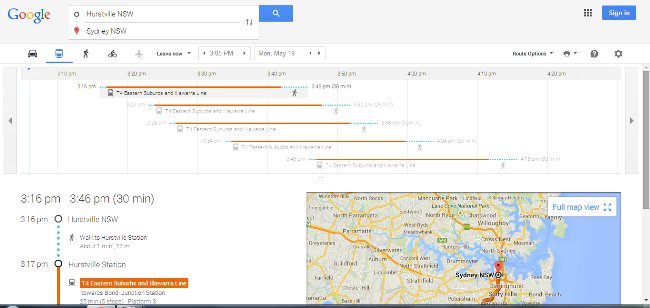
It’s as simple as going to the site, typing in “<Place A> to <Place B>” and selecting the little train symbol just above the list of directions. Google Maps not only provides the name of the train line or the bus number, it also tells you what time it arrives at your stop.
Note: Only useful if your public transport actually follows the schedule!
I especially love this feature when I’m overseas and have no clue what bus goes where, or which stop to get off. It really helps when I can’t read the language.
It can also provide walking and cycling directions, and local flights. You can find the full list of cities where public transport is covered here.
#2 See real-time traffic conditions
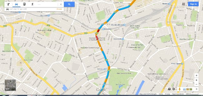
If you’re driving, you can zoom in on the map and see the traffic conditions on your route. Blue means conditions are as normal, yellow means mild congestion, red means congestion, and dark red means you’d better have some good music on your stereo because you’re going to be there a while.
You can also search for traffic near a place by simply typing “traffic near <place name>”. In this case, free-flowing traffic is green instead of blue. It’s very useful when you want to know what traffic is like along your usual routes, so you can detour if necessary.
#3 Explore an area
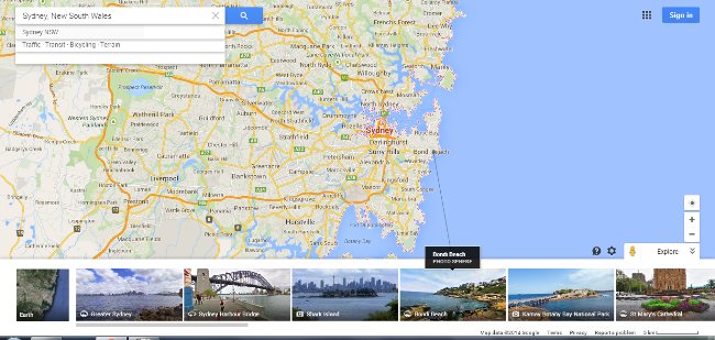
You can choose a city you’ll be visiting (or even your own, if you’re so inclined!) and click on the little photo and arrow icon on the bottom right corner of Google Maps. It’s just below the “+” and “-” buttons for zooming in and out.

This pops up a strip along the bottom of your page which lists many popular sights in the area. You can click on them to see photos of each attraction, and it even draws a line to show the exact location on the main map. It’s a great way to plan a trip, and get an idea of what you want to see. Or for those who can’t afford to travel, it’s also a great way to have a mini-holiday from the comfort of your own home!
What Google Maps features do you like to use, or find particularly useful? We’d love to hear about them in the comments!